UK weather: when is it going to improve? How many times have you found yourself complaining about the weather this week? The lack of summer-like weather seemingly continues to be part of the national conversation. While temperatures creep up closer to the average for June in the coming days, it won't feel like it because of rain and strong wind. And there are no signs of a significant improvement for the weekend and beyond. Rain is spreading east across many parts of the United Kingdom on Thursday, making the disappointing feel of the weather drag on. With wind gusts of up to 50mph around Irish Sea coasts accompanying the rain and temperatures of 11 to 16 degrees, it's more typical of an autumn day. And with low pressure sitting across the UK in the coming days, we will continue to see showers, longer spells of rain and a brisk wind at times. While that might make you reach for your jackets and warmer clothes, there will also be some sunnier interludes. When the Sun comes out and the breeze occasionally eases off, our wardrobe choices will be questioned.
As we approach the summer solstice on 20 June, the Sun is at its strongest in the year so it will feel very warm on your skin.Over the UK there are blue colours indicating colder air originating from the Arctic.
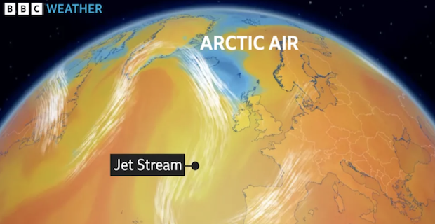
White streamlines indicating the jet stream is meandering and diving to the south of the UK.The Jet stream has been diving south in the eastern Atlantic and into central Europe
Why is it so cold?
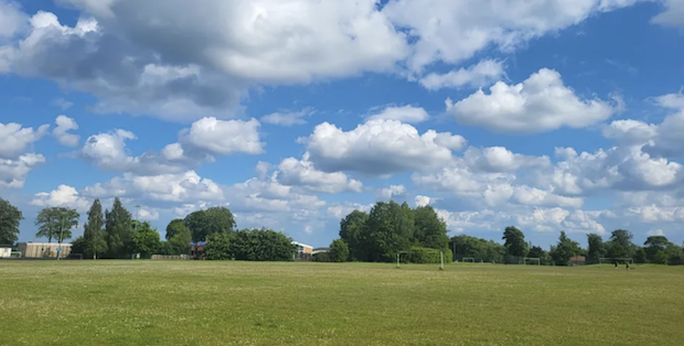
Earlier in the week the wind was coming in from a northerly direction and therefore dragging in colder air from the Arctic.While the wind direction changes more to a westerly into the weekend and the temperatures rise slightly, it will still feel cool at times.The main reason for the cooler than average weather is down to the jet stream - fast moving wind high in the atmosphere - which is positioned to the south of the UK.As the jet stream is the dividing line between Arctic air to the north and Tropical air to the south, its position is key for our weather.Since the start of June the jet stream has been positioned to the south and can typically bring areas of low pressure to the UK.As a side consequence, this pattern was also responsible for stormy weather in southern Spain and into central Europe.In the summer months we would typically expect the jet stream to head to the north of the UK, allowing warmer air to move in.view of a green field with green trees in the distance. There are sunny spells and fluffy white cumulus clouds in the sky
When is it going to turn warmer?
There are no signs of any signifcant change to the weather in the short term.A northward shift in the jet stream is what meteorologists are looking for.There are some weather computer models suggesting this might happen towards the end of June and into July. But, with other models not showing this, there are uncertainties in the longer term forecast.You can stay up to date with our thoughts with our Weather for the Week Ahead or further ahead in the monthly outlook.Is this cooler June weather normal?We are still very early on in summer. You might not even mark the start of summer until the solstice.But this cooler spell is coming after the warmest May and spring on record for the UK.It is also in stark contrast to last year which saw the warmest June on record.

On 10 June 2023 it reached 32.2C in Chertsey, Surrey and daytime temperatures were at least 25C for a fortnight with high humidity.
With high pressure dominating, it was also very dry. Manston in Kent went 33 days straight without rainfall.It is also worth noting that in both 2015 and 2019, June started cool but temperatures rose in the second half of the month.In 2019, the summer turned out to be record-breaking.On 25 July the temperature peaked at 38.7 C at Cambridge Botanical gardens, a new UK record at the time.There are no suggestions this is going to happen in 2024 but with more than a couple of weeks of June to go, we will have to wait for the statistics to know if it is a "normal" month or not. BBC NEWS


 Prime Minister Keir Starmer's 2025 Easter message
 After Nesil Caliskan a by-election will be held in Jubilee ward in Enfield
 Publishing the analysis, Labour’s Cllr Ergin Erbil said Everybody in Enfield deserves basic rights
 Gaza-Israel conflict Statement from Cllr Ergin Erbil, Leader of Enfield Council
 The European Union called on Turkey to uphold democratic values
 Turkish citizens in London said Rights, Law, Justice
 The Council of Turkish Cypriot Associations Geneva response letter
 Sustainable Development and ESG, Will This Become the Course for Turkic World
 The 'Prince of Paris' has impressed in his first EuroLeague season
 Saran Media And Euroleague Basketball Extend Media Rights Partnership for Four More Years
 Will Rangers be Jose Mourinho’s next victim?
 Jose Mourinho's Fenerbahce face Rangers on Thursday
 Barclays has become the biggest UK lender so far to cut mortgage rates
 THE SPRING STATEMENT EXPLAINED, UK ECONOMIC OUTLOOK AND GROWTH FORECASTS
 Launch of Made in Enfield gift shop to celebrate local artists and designers
 Trial used smart Wi-Fi sensors for live building occupancy data to optimise
